They are also faced with a range of challenges, including social inequality, poor air quality, vulnerability to climate related risks like flood or heat waves, wellbeing and health issues, all of which reduce their capacity to function properly.
At the same time, cities have the potential to re-integrate biodiversity in their premises and re-connect citizens to nature and improve their wellbeing.
However, JRC research reveals that this potential is untapped, even if European cities are performing quite well regarding the availability of public green spaces per dwellers.
On average, the available public green space per dwellers in Europe’s urban areas match the World Health Organization (WHO) guidelines.
However, there is a considerable variability between cities in this respect.
The researchers of the JRC's EnRoute project looked at nearly 700 core cities and urban areas across the EU.
The final report of the project is presented at a Committee of the Regions conference this week.
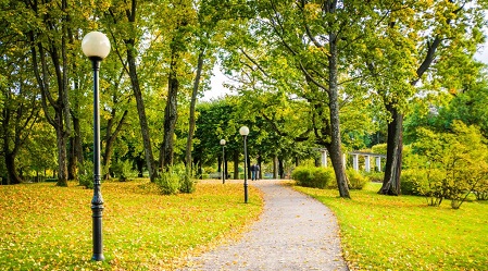
The research included cities like Vienna, which has a large forest covering nearly half of its land - and Rome, which has green spaces but also a very dense community to share it amongst.
One of the key finding of the study is that there is a clear north-south gradient with a higher availability of publicly accessible green areas in northern cities.
This gradient depends on the public parks availability on one hand and on population density on the other hand.
Another key finding is about the huge amount of urban land actually covered by green spaces.
On average 40% of the land covered by Europe's cities are green areas like urban greens, private gardens and urban forests.
In addition, 15.2% of Natura 2000 network falls within the boundaries of cities and their commuting zone. That means that cities can also play a role in biodiversity protection.
These differences, and our growing population, highlight that there is an uneven opportunity for citizens to access nature-based recreation opportunities in Europe.
The study found that efforts are being made across Europe, but much of the potential remains untapped.
In fact, on average 35% of the surface area of Europe's Functional Urban Areas, the cities and their commuting zone, consist of land that has a high potential for nature-based recreation.
This includes areas like green land with trees, urban forests, meadows, open water areas and Natural Protected areas.
However, less than one-third of this land (7% of the surface area of EU Functional Urban Areas) also has a high availability of 'recreation-supporting facilities' - things like playgrounds, cycle paths or picnic areas.
Beyond the health and wellbeing benefits of providing the opportunity for people to spend time outside and enjoy the green spaces in and around their neighbourhoods, green infrastructure also plays an important role in protecting our environment.
This is particularly true for resilience against floods, a challenge that will continue to grow as the frequency and severity of floods in Europe increases in the coming decades.
The study finds that an average of 46% of Europe's urban area has a low capacity to mitigate floods.
This often includes land that has been paved over, preventing water from being absorbed by the soil.
Even small patches of green space, whether public or private, can contribute to mitigating flood risk in cities. Strategically implementing green infrastructure will therefore be an essential nature-based solution to address this challenge.
The EnRoute project included a 'citylabs' initiative - collaboration between scientists and 18 cities across Europe, from Dublin in Ireland to Limassol in Cyprus.
Teams worked on specific policy questions for each participating city, like developing open spaces along Poznan's river network, or a plan for healthy urban living in the growing city of Utrecht.
Through the project, cities have been able to share good practices and establish a strong connection between scientific evidence and implementing policies that can improve lives for their inhabitants.
The project also led to the creation of an EU knowledge base on urban green infrastructure.
This is important because it can support countries, regions and cities with the collection of relevant data, methodologies and tools to support local initiatives and planning involving urban green infrastructure.
The data collected in this EU wide assessment will be made available on the JRC data catalogue.
The results highlight the importance of maximising the quality and availability of urban green infrastructure.
The methodologies developed under the EnRoute project have also been successfully used at a local level to support cities in mapping suitability of land to support insect pollinators and to map the availability of opportunities for nature-based recreation.
Urban green infrastructure refers to the strategically managed network of urban green spaces and natural and semi-natural ecosystems situated within the boundary of an urban ecosystem, and which provide nature benefits (ecosystem services’) to people.
These high-quality, biodiversity-rich areas can help make cities more sustainable and contribute to solve many challenges, such as air pollution, noise, climate change impacts, heat waves, floods and public health concerns.
As cities grow and develop, it is vital to improve the availability, quality and accessibility of urban green infrastructure.
Managed by the European Commission and funded by the European Parliament, the EnRoute (Enhancing Resilience of urban ecosystems through green infrastructure) project supports these efforts and delivers a knowledge base to feed into the evaluation of the EU Biodiversity Strategy and potential discussions on new biodiversity targets.
The primary data source for the project and final report is the EU's Urban Atlas. Developing, maintaining and updating high resolution data of the distribution of urban green space and the benefits it delivers proved to be a common conclusion of the project's city labs.
Both the EU's Copernicus satellite programme and local data collection – both by cities and through citizen science -will become essential data providers in continuing to support urban green infrastructure policy and management.
The EU is also dedicating a whole area of Research and Innovation on how nature based solutions can help tackle urban challenges, though living labs and large scale demo in cities and replication of the successful models all across Europe (currently more than 70 cities are involved in a EU Research and Innovation project, Horizon 2020 programme).

La mejor actitud que podemos adoptar es la de trat...

El equipo de investigadores observó cambios en el...
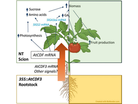
El gen AtCDF3 promueve una mayor producción de az...
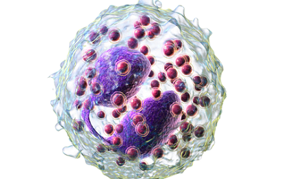
En nuestro post hablamos sobre este interesante tipo de célula del si...

Un nuevo estudio relaciona las temperaturas elevadas en la primera inf...